Run Isle Royale: A Remote Wilderness Island With More Moose Than People.
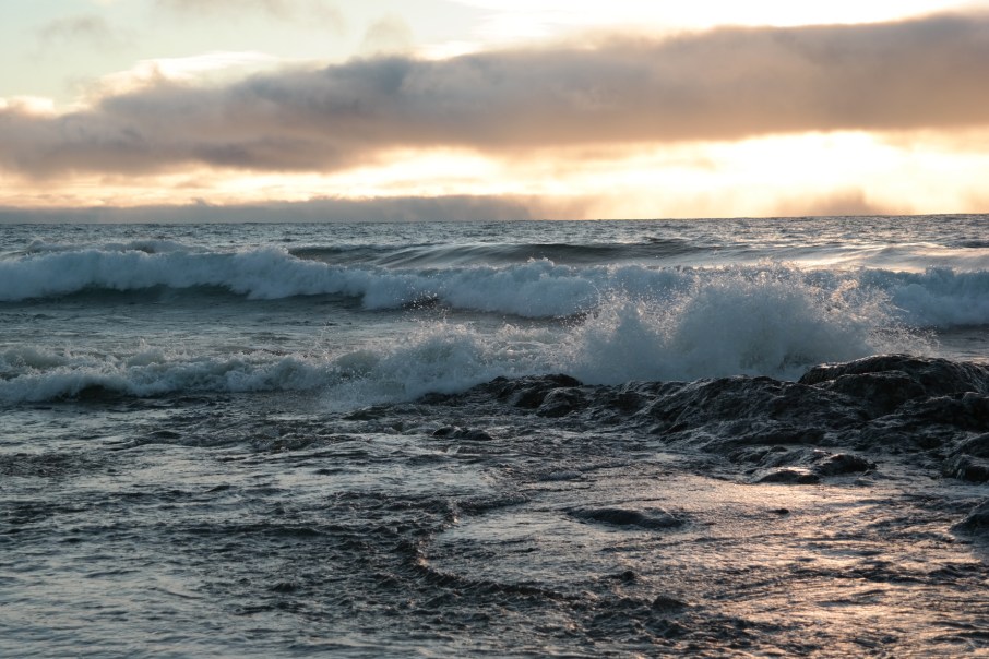
Fall Sunrise over Lake Superior, MN North Shore
Run Isle Royale
Endurance/ Fitness Rating: 1-4 (Choose Your Adventure)
Trail Technicality Rating: 3
Logistics Rating: 5
Scenery Rating: 4
Backcountry Gear Required: 4
Wilderness At Its Very Best:
At a trickle of 18,000ish visitors per year, Isle Royale brings up the rear in the popularity race among the US National Parks, consistently falling to dead last among the National Parks in the lower 48 states. But lest you mis-infer the reasons for this statistic, read stat #2: Isle Royale consistently boasts the highest return-rate for visitors than any other US National Park.
Remote, Undeveloped, Ancient, and Wild:
When you visit Isle Royale, it’s immediately obvious that access is simultaneously the biggest barrier and the best asset for the Island’s popularity (or lack thereof). Let me set this up for you: If it isn’t bad enough that this secret North Star is buried in the most remote tip of flyover country, its two mainland access harbors are a minimum of 5 hours drive-time from the nearest international airport(s) (Minneapolis or Milwaukee). At the end of this drive, you’ll find the Island is still so far away that you still cannot see it with binoculars.
The Island is surrounded by a crystal clear, ice-cold moat of some of the most treacherous land-locked waters (having caused over 6,000 shipwrecks) in the world. You must cross this expanse in a 6 hour boat ride from Copper Harbor/ Houghton MI, or a 3 hour ride from Grand Portage MN, to reach respective East/ West ends of the Island. This trip is not for the faint of heart; water conditions can be downright oceanic. To complicate things further, the island is only typically accessible from mid-May to early October, depending on the ice pack and weather. The shoulder seasons can be finicky and the waters can be dangerously rough, so boat service off-peak is perhaps only 3 times per week and subject to change as it does not run at all in poor conditions… as Gordon Lightfoot put it: “Superior, it’s said, never gives up her dead when the gales of November come early” https://www.youtube.com/watch?v=9vST6hVRj2A
Trip Hacks
Best Time to Visit: For an authentic true wilderness experience, take the first or last few boats of the year to the island. During these shoulder seasons, there are very few visitors and therefore boat access is limited. For more information on available transportation, see NPS Isle Royale Transporation Info.


There are distinct advantages and disadvantages to early spring and late fall trips to IRNP, and they are important to consider.
Spring Option: To set foot on an island that has been void of people aside from a handful of researchers through the winter months is truly a unique experience. My brother in law, an ultra runner known as Minnesota’s “Iron Ecologist” made this trip with some ultra friends on the second boat of 2016. Being one of the first to set foot on the freshly melted trails brought advantages of finding ample moose sheds and discovering rare forbs opening up along the trails.
Fall Option: I personally prefer the last boat of the year to make this trip; the fall weather is equally unpredictable, but accompanied by the fall colors which are pretty dynamic in the dense maple forests on the island, and full moose rut which can be interesting. Either way if you choose these first or last boats of the year, you have limited access dates and boat options, and island luxuries are not available. During my fall trip there was one potable water source still running at Windigo, and all buildings aside from the permit station were shut down. On the day I caught my boat ride home, the NPS were pulling the docks out of the water using a boat crane, and I was one of 9 people remaining on the island.


For a side by side comparison of the two seasons, I’ve broken it down for you here:
General Shoulder Season IRNP Information |
Spring Option |
Late Fall Option |
| Crowds
Isle Royale is the least visited National Park in the U.S., but with the highest rate of “return visits” of any park in the U.S. That pretty much says it all. If you go during shoulder season as I recommend, you could be one of as few as 12 guests on the 45 mile island. |
Crowd avoidance is important as all wilderness campsites, including 3-sided screened huts at Windigo, are first-come, first-served.
The rustic huts make excellent base-camps, particularly in wet weather. |
Crowds are nominal at best during last 2-3 boats of the season.
Again, all campsites including 3-sided screened huts at Windigo alongside are available on a first-come, first-served basis. The rustic huts make excellent base-camps particularly in wet or cold/ windy weather. During my late fall trip in 2014, I was one of 12 visitors remaining on the island and stayed in a hut at Windigo. |
| Wildlife
You will complete a brief, mandatory wildlife safety orientation upon arriving at IRNP. This is one of the best places in the world to view Moose, as there are currently around 1200 in the island. There are also very few remaining wolves (population has shrunk due in part to inbreeding, more info can be found here: http://www.isleroyalewolf.org/node/170) You are also likely to see wiley fox who will steal unattended gear or food, and hares, and beavers on the island as well as Gray-jays that may steal your trail mix. No bear or deer populations on IR. |
In Spring, moose have calved, be on alert for fresh cows as they are defensive of their young and will become dangerously aggressive; keep a safe distance. | Moose are in full rut in late September- Bulls have poor eyesight and will see you as a potential threat, so keep a good distance and steer clear. Rut calls are audible especially near Windigo. |
| Weather | Volatile- snow showers are common, rain is common.
Transportation back to mainland can be delayed if winds are high, so plan buffer days. In May, historical average low is 36 degrees, high is 60 degrees, average monthly rainfall is 2.7” and snowfall 0.83”. |
Volatile- can range from crisp fall evenings and warm days to the gales of November coming early, and gales are no joke. For example of these variations in weather, on September 3, 2010, a cyclone moved along the Canadian shoreline of Lake Superior. Significant winds, with gusts as high as hurricane force, as well as 23 foot waves were documented. With this in mind, transportation back to the mainland back can be waylaid if conditions aren’t safe, and you won’t be able to contact anyone off the island, so plan some buffer travel days if possible.
In September, the average low is 41 degrees, average high is 63 degrees, rainfall is 3.4” and snowfall is 0.16”. |
| Scenery | Early flora are appearing along the trail and tree foliage is minimal. While the forests’ shades of gray and brown might not be as pretty, it makes wildlife much easier to spot and view. Mosses along the northside of island will be bright spring green and moose sheds are plentiful along the trails. | Dense maple forests are blazing with fall color, and island is in full foliage.
Moose viewing is prime as they are emboldened by rut. Keep your eyes and ears open, and avoid using headphones if you are alone. |
| Logistics and Access
General list of access points and modes of transport can be found here: https://www.nps.gov/isro/planyourvisit/directions.htm Please note that during early and late shoulder seasons, typically only one boat runs from each access point. From Grand Portage, the early and late season vessel is the Voyageur II and the schedule is limited, with typically only 2 outbound or inbound visits to the island per week. The Voyageur II will only travel to the main harbors during shoulder season so make your reservation specific if you plan for a drop elsewhere on the island. |
Spring Schedule for Voyageur II:
May 7, 2016 – May 29, 2016: Outbound trips to island Wednesday and Saturday; Inbound trips from island Thursday and Sunday. (This info subject to change) |
September 21, 2016 – October 6, 2016: Outbound trips to island on Wednesday; Inbound trips from island on Thursday; Saturdays and Sundays back and forth to Windigo each day and depart Grand Portage at 8am and Windigo at 1pm. (This info subject to change) |
Routes:
There are many, many routes a person could take at IRNP and many other blogs which cover these. You can arrange a drop off at one end of the island and fast-pack the entire thing, or you can set up a base-camp (Windigo is my base camp of choice) and go out on loops ranging from 9-40 miles. Bear in mind when planning your adventure than the primary source for filtering your water should be Lake Superior, and camping outside of designated areas is illegal.
Pro Tip: For more technical trail that looks like moss covered faerieland and much less human traffic, take the Minong Trail over the ever popular Greenstone Ridge Trail.
Keep a tidy camp!
This is always a good rule, but especially on Isle Royale. When I visited, there were red squirrels abound and a wiley fox that did rounds through the Windigo shelters. The fox was reputed by the Rangers to have nabbed everything from food, to T-shirts, a sock, and even a digital camera left unattended for mere moments. Be especially wary of your cook kit, as your tools and meals will smell enticing to these critters. Pro tip: Patagonia just released a water-repellant black-hole cube storage system, that I tried out on an expedition this summer. One of these cubes perfectly packs 2-3 MSR 20 oz fuel bottles (for longer trips or group cooking), a Dragonfly stove (or comparable backpacker’s stove), lighters and windshield, with zippered pockets and a fold-open style for convenience.

Don’t Leave Home Without:
- Water Filter: I recommend the Sawyer 2.0 L Gravity Filtration System. During shoulder seasons, potable water sources are turned off, but Lake Superior offers an excellent filtering water source at the majority of camp sites (it will taste better than tap water). It is not recommended to filter from most inland water sources at IRNP, so bring a 2-3L bladder for trail hydration to minimize added spur miles down to the water.
- Stove and Fuel: Campfires are not allowed at most campsites at IRNP, so your stove is your only heat source. I use the MSR Dragonfly for its fuel efficiency and versatility, reliability in extreme conditions But I am also a big fan of Jet Boil minimalism for solo trips. You can’t go wrong either way.
- Emergency food: 1-2 meals for lightweight emergency food supply (in case the boats to mainland cannot run as scheduled). I like Patagonia Provisions Black Bean Soup.
- Trail Running/ Fast Packing Layers: I always recommend the hooded Houdini Jacket (You’ll see this on nearly every gear list I make, it’s extremely versatile, wind and water resistant, and packs down smaller than a cell phone to stash away easily in your pack).
- Base-layer(s): 2 tops (one lightweight capilene, and one warmer layer), 1 pair bottoms. Consider the dry-time of fabrics before you pack your layers. Weather on Isle Royale can vary by the hour and there’s nothing worse (or more dangerous) than wet layers in cold weather.
- Rain Gear: This is a must. (My kit includes the Patagonia torrentshell jacket and pants, a non-cotton brimmed cap, Dirty girl gaiters to keep wet debris out, and Salomon Speedcross Climashield/WP and Smart-wool socks).
- Insect Repellant: This isn’t as paramount during shoulder seasons, but bugs can be unpredictable. I recommend Pecarin repellant over DEET. Skin-so-soft makes an excellent Pecarin repellant product that works better on the trifecta of black flies, biting gnats, and mosquitos than DEET does in my experience—and it doesn’t smell like a chemistry lab.
- Sleeping Bag and Shelter: 30 degree sleeping bag for shoulder season. The Island is more exposed than mainland, and Lake Superior is the world’s largest air conditioner, so err on the side of colder conditions when you pack.
- Wool beanie, Buff, and Gloves. I bring a couple of hot hands hand warmers (1-2 packages just in case). Lighting camp stoves takes dexterity, and no one wants the screaming-barfies,
- Good old-fashioned trail topo-maps (I keep mine in a ziplock). You will have lost cell service an hour south of Grand Portage, so you certainly shouldn’t expect to have it in the middle of Lake Superior.
Isle Royale Geography:
The island is 45 miles (72 km) long and 9 miles (14 km) wide, with a total surface area of 207 square miles, making it the largest natural island in Lake Superior. Isle Royale is 15 miles from the Canadian and Minnesota shorelines of the lake, (near the cities of Thunder Bay, Ontario and Grand Portage MN), and is 56 miles from the Michigan shoreline, on the Keweenaw Peninsula. There are no roads or vehicles on the island.
Here’s a fun fact: Siskiwit Lake is the largest lake on the island. Siskiwit Lake contains islands, including Ryan Island, which contains Moose Flats (a seasonal body of water), which contains Moose Boulder. When Moose Flats is flush with water, Moose Boulder becomes “the largest island in the largest lake on the largest island in the largest lake on the largest island in the largest lake in the world.”
The island is composed largely of ridges, running roughly southwest-to-northeast. The main ridge, Greenstone Ridge, is over 1,000 feet (300 m) in many places and offers expansive views of Lake Superior and the Canadian mainland. Greenstone belts are exposed in places, with rounded stones of chlorastrolite or greenstone near and in the lake.
Island History:
The island was a longstanding hunting ground for native peoples from nearby Minnesota and Ontario. A paddle of thirteen miles was necessary to reach the island’s west end from the mainland, which wasn’t necessarily “far” considering the abilities and habits of native paddlers in that era. What’s more impressive to me is what that distance really means on the moody waters of Lake Superior which has boasted swells of 20 feet.
Long before Objibwa hunters, the Island bore other riches. In prehistoric times, copper was mined on Isle Royale and the nearby Keweenaw Peninsula. The region contains relics from ancient mine pits and trenches up to 20 feet deep. Copper artifacts from the area have found to be at least 5700 years old. (Take a moment and think about that… that’s 3362 years before Aristotle, 4170 years before the fall of the Roman Empire, and 5190 years before Columbus… that’s a LONG time ago).
Isle Royale was given to the United States as a result of the 1783 treaty with Great Britain, but the British remained in control of the territory until after the War of 1812. The Ojibwa peoples considered the island to be their territory until they ceded the island to the U.S. in the 1842 Treaty of La Pointe. Not surprisingly, there was some dispute over this for a few years thereafter, as the Ojibwa peoples of Grand Portage had no idea that they, nor Isle Royale, were ever considered British Territory to begin with.
In the 1840s Douglass Houghton, namesake of the aforementioned Michigan port city and first known geologist in the state of Michigan, ignited a copper-rush in the state, and thus the first modern copper mines were opened on Isle Royale. Evidence of the ancient mines was abundant to modern miners, in the form of stone hammers and copper artifacts. The ancient pits and trenches led modern miners to the discovery of many of the copper deposits that were mined in the 1800s. However, the remoteness of the island and harsh seasonal weather, combined with the relatively small veins of copper caused most of the 19th-century mines to fail quickly. Between mining efforts and logging, much of the island was deforested during the late 1800s. The island finally became a National Park in the 1940s, and forests have since begun to regenerate and flourish.
Run the Wilderness: US National Parks Backcountry Camping Best National Parks Best Trail Runs Greenstone Ridge Hiking Isle Royale Minong Trail Moose Patagonia Running Gear Sawyer Smartwool Through Hikes Through Hiking Trail Running Ultra-Running Wilderness Camping Wilderness Running
